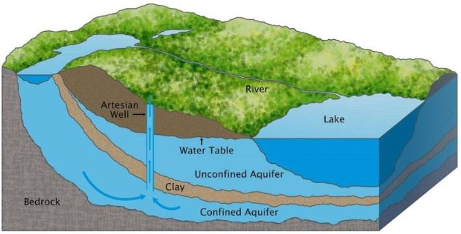
An illustration of different types of the aquifer (Gunther, 2011)
Groundwater is the water beneath the land surface that fills the spaces in rock and sediment.
According to “Groundwater-Minnesota DNR” (n.d.), about 75% of our drinking water, and 90% of agricultural irrigation water is groundwater. Groundwater is a finite resource; the pure water that we pump out today may take thousands of years to recharge. Besides, once the contamination enters groundwater, it is tough to clean up. Therefore, to ensure the safety and sustainability of our water supply, the groundwater needs to be investigated and closely monitored.
Due to the hidden and complex natures of groundwater, it is often undervalued by researches and the public. Groundwater is poorly understood yet desperately needs attention; in this circumstance, the Groundwater web app was developed for both academic support and dissemination proposes. The groundwater web app explains basic knowledge, visualizes the spatial-temporal information, and shows statistic and analytic results. Based on the currently existing data sources, the web app consists of 6 major sections: 1) Introduction, 2) Summary Charts, 3) Well Observation Data, 4) MPARS Data, 5) Other Analysis Maps, 6) Get Data.
When a water-bearing porous soil or rock strata able to transmit a fair amount of water to wells and springs, it is called an aquifer.
For section 2, 3, and 4, the data can be viewed separately for Water Table Aquifers, Buried Artesian Aquifers, and Bedrock Aquifers.
“Groundwater Basics - Minnesota DNR” (n.d.) provides detailed information of these aquifer types.
Water Table Aquifers are the saturated portions located above a confining layer. Below the confining layer, Buried artesian aquifers are composed of glacially deposited sands and gravels, and Bedrock aquifers are geologic bedrock units that have adequate porosity and permeability.
Please be aware that the raw data contains some records that have ‘Unknown’ or ‘null’ aquifer types, so we also included pages to show all data together.
The two major datasets of our app are observation well and MPARS. The observation well dataset records the water level and water quality monitor data since 1945. The MPARS dataset records the permitted usage and the actual usage of each pump well. Both two datasets are visualized in the spatial-temporal format in section 2, 3, and 4. By clicking the maps in section 2, our app will show the zonal statistic result for water level, water withdrawal, and precipitation. To look closely into well observation data or MPRAS data, please go check out section 3 or 4.
For the researches, our app is a great start point, which gathers and visualizes current existing data and ease the research process. For the public, our app appeals to the audience to pay attention to groundwater protection. The app will be updated when new sources are available.
References:
Groundwater - Minnesota DNR. (n.d.). Retrieved August 13, 2019, from https://www.dnr.state.mn.us/waters/groundwater_section/index.html
Groundwater Basics - Minnesota DNR. (n.d.). Retrieved August 14, 2019, from https://www.dnr.state.mn.us/waters/groundwater_section/terms.html
Gunther, T. (2011). Illustration. An aquifer is an underground layer of rock that holds groundwater. National Geographic. Retrieved from https://www.nationalgeographic.org/media/aquifer-illo/